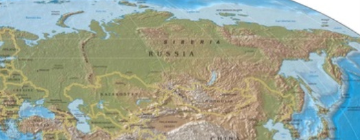
Russia and the Newly Independent States
This region is made up of the countries formed when the Soviet Union ceased to exist. They inherited problems to solve and challenges along with their freedom and have had to work though many difficulties as they move forward as young nations.
There are twelve countries in this region: Armenia, Azerbaijan, Belarus, Georgia, Kazakhstan, Kyrgyzstan, Moldova, Russia, Tajikistan, Turkmenistan, Ukraine, and Uzbekistan
There are twelve countries in this region: Armenia, Azerbaijan, Belarus, Georgia, Kazakhstan, Kyrgyzstan, Moldova, Russia, Tajikistan, Turkmenistan, Ukraine, and Uzbekistan
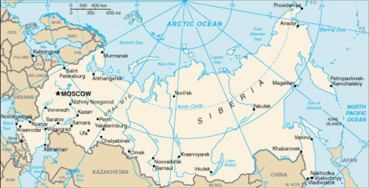
Physical Features
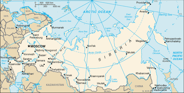
Ural Mountains
The Ural Mountains run north and south and have been considered to be the separation between Asia and Europe. They are not an imposing mountain range that and extend from the Arctic Ocean all the way to Kazakhstan. They do not impede moisture from crossing to the Siberian Plain from the Atlantic Ocean or the Baltic Sea. They also have passes that make human transport through the area quite simple (Pulsipher & Pulsipher, 2008).
The Ural Mountains run north and south and have been considered to be the separation between Asia and Europe. They are not an imposing mountain range that and extend from the Arctic Ocean all the way to Kazakhstan. They do not impede moisture from crossing to the Siberian Plain from the Atlantic Ocean or the Baltic Sea. They also have passes that make human transport through the area quite simple (Pulsipher & Pulsipher, 2008).
Aral Sea
The Aral Sea is located west of the Caspian Sea and at one time was the fourth largest lake in the world. This has changed in the last fifty years as massive irrigation projects have diverted much of the water that was moving into the sea. The sea had been fed by the Syr Darya and Amu Darya rivers which brought snow melt down from the mountains. These rivers were diverted into canals that traveled great distances and much of the water was lost to evaporation. The sea had lost seventy five percent of its volume by 2001 and formed three smaller lakes, causing damage to ecosystems and even the weather. Without the temperate control of the large water mass, the growing season in the area is almost three weeks less and affects crop yields (Pulsipher & Pulsipher, 2008).
Central Siberian Plateau
The Central Siberian Plateau is east of the West Siberian Plain and has its east-west borders as the Lena and Yenisey rivers respectively. The northern border of the area is the Siberian Arctic Lowland which leads down to the Arctic Ocean. The plateau has large deposits of minerals including iron are, diamonds and mineral fuels. The area has elevations of over sixteen hundred feet with numerous rivers cutting through the limestone and clay. These rivers form gorges that are perfect for hydro electric power plants to be constructed (Central Siberian Plateau, 2011).
Volga River
The most important river in European Russia is the Volga. This river is a major transportation hub for the region. It is connected to much of the North European Plain and the Baltic, White and Black seas. This is accomplished through a system of canals, lakes and natural tributaries that allow movement of people and goods throughout the area. It is the longest river in Europe and travels almost 2,200 miles to empty into the Caspian Sea. The river is also used for irrigation, flood control and power production besides its main transportation function (Volga River, 2011).
Caucasus Mountains
The Caucasus Mountains are actually two ranges that lie in parts of Azerbaijan, Armenia, Georgia and Russia between the Black and Caspian seas. The highest peak in the Caucasus’s is Mount Elbrus which rises to 18,510 feet in the Greater Caucasus range and the other is the Lesser Caucasus range. The mountains were formed by the collision of the Arabian and Eurasian plates and are subject to earthquakes as those plates continue to move. The resources in the area are large granite and petroleum reserves along with natural gas deposits (Caucasus Mountains, 2009).
Climate
The climate over most of the region is continental, being either winter dry or moist all year. This area extends from the European Russia all the way across to the Pacific Ocean. The summers are short and the winters long and cold. They don’t receive large amounts of moisture from either ocean and therefore have short growing seasons that require irrigation. The northern reaches of the region extend into arctic conditions with permafrost and containing large areas of northern conifer forest or taiga. The southeast area of the region has Desert and Steppe climates as the result of their position in the middle of such a large continent. This area has very hot, arid summers followed by long intense winters (Pulsipher & Pulsipher, 2008).
Resources
This vast region has an abundance of natural resources which have been of vital importance to their industrial development, but their harvesting has created many environmental issues. The region boasts the world’s largest reserve of natural gas and Russia alone is second only to Saudi Arabia in the export of oil. These recourses alone have helps the region eliminate much of the debt left from the USSR during the time worldwide energy prices were at their peak. This has come at some cost however, as Siberia has contaminated rivers and lakes from inland oil spills. There is also a push to build new pipelines to ship the oil and environmental concerns are not at the forefront (Pulsipher & Pulsipher, 2008).
The mountain areas of the region contain minerals and major deposits of coal. They are extracting “iron ore, lead, mercury, copper, nickel, platinum and gold” (Pulsipher & Pulsipher, 2008). These resources are either exported or used by the industrial framework of the region. The area also creates the third largest amount of electricity through use of hydroelectric technology. Timber is also a major resource to the region as it contains one-quarter of the world’s forests. Unfortunately, because the governments need rapid capital, it is being clear-cut at an unsustainable rate (Pulsipher & Pulsipher, 2008).
The mountain areas of the region contain minerals and major deposits of coal. They are extracting “iron ore, lead, mercury, copper, nickel, platinum and gold” (Pulsipher & Pulsipher, 2008). These resources are either exported or used by the industrial framework of the region. The area also creates the third largest amount of electricity through use of hydroelectric technology. Timber is also a major resource to the region as it contains one-quarter of the world’s forests. Unfortunately, because the governments need rapid capital, it is being clear-cut at an unsustainable rate (Pulsipher & Pulsipher, 2008).
Environmental Issues
The region is still affected by the Soviet ideology “that nature was the servant of industrial and agricultural progress, and the grander the evidence of human domination over nature, the better” (Pulsipher & Pulsipher, 2008). This policy caused extensive damage to the environment in much of the region. The people in the region are also affected as fifteen percent of the population of the region live in an area where the soil was poisoned and air pollution is toxic to humans. Birth defects are rampant in these areas and thirty three percent of adults in some urban areas have respiratory problems related to air pollution. The pollution results from the burning of fossil fuels, oil spills, fertilizer-pesticide runoff and nuclear radiation. The region is the place of the worst nuclear disaster in the world. The results of the explosion at the Chernobyl power plant are wide spread and have created wide tracks of land that cannot be used for the foreseeable future. The radiation pollution is even stronger in areas around former military installations. There is one that has twenty times the radiation in the soil that was released from Chernobyl (Pulsipher & Pulsipher, 2008).
Population Patterns
The most significant change in the population patterns of this region have come as a result of the breakup of the Soviet Union. Since this time the region's population has declined. Adult life spans have fallen and child and infant mortality increased, possibly brought on by the social disruption and accompanying stress from lost jobs. Suicide rates for men have increased as alcohol abuse has skyrocketed. Russia has the largest difference in the world, thirteen years, between male and female life spans in peacetime. Another problem involved people having a lower quality diet as food became harder to get and what was available was so expensive that half of a family’s budget could be spent on food. All the problems that the people face has also prompted families to have less children and this has caused birth rates to decline when the region already had a low rate, adding to the decline (Pulsipher & Pulsipher, 2008).
The Role of Gender
Women have long been encouraged to work outside the home by Soviet policies and that has continued through communist breakup. Women work long hours in the fields or in the factories and then are expected to go home and take care of all the family business as well. A major difference in this region is that on average, women of the region have more education than their male counterparts. This does not help them however in attaining equal pay as even though they hold jobs that require education they are paid an average of thirty six percent less than men and do not hold supervisory positions. In Russia, factory worker are paid more than women who are engineers or physicians. These inequities have pushed many women to try to emigrate from the region to other parts of the world. Many of these women are being tricked or trapped into unsavory sex trade that is now targeting women with a European look (Pulsipher & Pulsipher, 2008).
Religions
The Soviet Union did not allow religion as they viewed it as contradictory to the good of the people. Since the emergence of the independent states, the interest in religion has been fueled by the attempts to revive past culture. Many in European Russia had ancestral connections to Orthodox Christianity and they, evangelical Christians and a minority of those with Jewish history have all had a revival. The restoration of sanctuaries destroyed by the soviets has been a major step in regaining their past (Pulsipher & Pulsipher, 2008).
The return to religion in the Central Asian republics has faced some difficulties. The predominate religion in the area is Muslim and despite many of the leaders being Muslim, they worry about the radical influences of states like Iran and Saudi Arabia trying to take them over. There had been a five year war against Islamic insurgents and now many are saying that in the rush to eliminate them, many Muslims who were not involved with the insurgence have been persecuted (Pulsipher & Pulsipher, 2008).
The return to religion in the Central Asian republics has faced some difficulties. The predominate religion in the area is Muslim and despite many of the leaders being Muslim, they worry about the radical influences of states like Iran and Saudi Arabia trying to take them over. There had been a five year war against Islamic insurgents and now many are saying that in the rush to eliminate them, many Muslims who were not involved with the insurgence have been persecuted (Pulsipher & Pulsipher, 2008).
Transportation
The region faces many challenges in developing an efficient land transportation system due to its size, varied landscapes and long winters. Compared to the United States, the region has two and a half times the land mass and less than seventeen percent of paved roads. The road the region does have are almost all two lane roads which cause traffic to be congested (Pulsipher & Pulsipher, 2008). The condition of most of the regions extensive transportation system is not good. Although they operate beyond capacity, they are in serious need of updating to meet the areas growing needs. Russia has always depended on railroads as a means of transportation and they built the Trans-Siberian Railroad to try to connect their large country. During Soviet control the railroads were expanded to as a prominent form of transport to and from Moscow (Transportation, 2011).
During his time, Peter the Great ordered the construction of St. Petersburg on the Gulf of Finland to give Russia a “window to the west” and marine access has been important to the region ever since. There are important ports in the east, north and west connecting the region to the Atlantic and Pacific Oceans. Russia alone had a merchant fleet of 888 ships in 2002 with the majority of them being cargo vessels. They are planning to build a new port for the countries oil shipments and will be to the southwest of St. Petersburg on the Baltic Sea (Transportation, 2011).
During his time, Peter the Great ordered the construction of St. Petersburg on the Gulf of Finland to give Russia a “window to the west” and marine access has been important to the region ever since. There are important ports in the east, north and west connecting the region to the Atlantic and Pacific Oceans. Russia alone had a merchant fleet of 888 ships in 2002 with the majority of them being cargo vessels. They are planning to build a new port for the countries oil shipments and will be to the southwest of St. Petersburg on the Baltic Sea (Transportation, 2011).
Agricultural Production
The agriculture in Russia is still dominated by the large collective farms established by the Soviet-Union that control most of the land. These farms are inefficient and use outdated technology and as a result did not improve production with the transition to the free market. The northern areas are used mainly for livestock and grain is the main crop in the southern and western areas. There is inconsistent rainfall throughout the region and the soil is not high quality, so much of the area is not suitable for growing. Three percent of the agricultural land is operated by small private farms and people with household plots and this land produces forty percent of all the country’s food. The country has 133 million hectares that can be used for agriculture and 14 percent of the countries people are involved in farming. The free purchase of land or the purchase by individuals for agriculture is not allowed by the Russian legislature. This inability of the farming people to buy land to work has meant that their overall productivity has remained low (Agriculture, 2011).
Country of Focus - Republic of Belarus
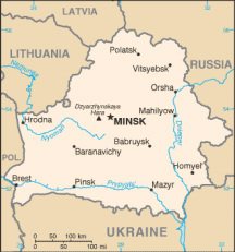
BELARUS
Belarus is a former part of the Soviet Union which gained its independence in 1991. The country is landlocked and has low-lying thick forests with flat marshlands and fields. The climate is between maritime and continental and they have cold winters and summers that are cool and moist. The population of fewer than ten million has a high literacy rate and enjoyed one of the best standards living during the Soviet rule. The country has small amounts of oil and natural gas and grows grains, potatoes and vegetables. They also raise both beef and dairy cattle. Their industry base is well developed and was created during the Soviet time (Belarus, 2010).
The type of government is officially a republic with their constitution calling for an executive branch, legislative branch and judicial branch. The first president took expanded powers by having an unrecognized referendum in 1996. He has continually consolidated and increased his power and control since then maintaining the presidency despite a constitutional limit of five years as president. His government restricts basic freedoms and due to his rule, little new foreign investment has been started and they continue to be dependent on Russia for support (Belarus, 2010).
The type of government is officially a republic with their constitution calling for an executive branch, legislative branch and judicial branch. The first president took expanded powers by having an unrecognized referendum in 1996. He has continually consolidated and increased his power and control since then maintaining the presidency despite a constitutional limit of five years as president. His government restricts basic freedoms and due to his rule, little new foreign investment has been started and they continue to be dependent on Russia for support (Belarus, 2010).
References
Agriculture. (2011). In Nations Encyclopedia online. Retrieved from: http://www.nationsencyclopedia.com/economies/Europe/Russia-AGRICULTURE.html
Belarus. (2010). U.S. Department of State: Diplomacy in Action. Retrieved from: http://www.state.gov/r/pa/ei/bgn/5371.htm#gov
Caucasus Mountains. (2009). In New World Encyclopedia online. Retrieved from: http://www.newworldencyclopedia.org/entry/Caucasus_Mountains
Central Siberian Plateau. (2011). World-geography.org. Retrieved from: http://world-geography.org/russia/762-central-siberian-plateau.html
Pulsipher, L. M., & Pulsipher, A. (2008). World regional geography: Global patterns, local lives. (4th Ed). New York, NY: W. H. Freeman and Company
The University of Texas at Austin. (2010). [Perry-Castańeda Library digital map collection]. Belarus small map, 2010. Retrieved from:
http://www.lib.utexas.edu/maps/cia10/belarus_sm_2010.gif
The University of Texas at Austin. (2010). [Perry-Castańeda Library digital map collection]. Russia small map, 2010. Retrieved from:
http://www.lib.utexas.edu/maps/cia10/russia_sm_2010.gif
The University of Texas at Austin. (2003). [Perry-Castańeda Library digital map collection]. World physical map, 2003. Retrieved from:
http://www.lib.utexas.edu/maps/world_maps/world_rel_803005AI_2003.jpg
Transportaion. (2011). In Nations Encyclopedia online. Retrieved from: http://www.nationsencyclopedia.com/Europe/Russia-TRANSPORTATION.html
Volga River. (2011). In Encyclopædia Britannica eb.com. Retrieved from: http://www.britannica.com/EBchecked/topic/632239/Volga-River
